I remember perfectly the first time I faced the Vinicunca elevation. The alarm went off at 3 a.m. in Cusco, and the cold dawn air seemed to carry a promise of adventure. As we climbed the winding roads in our private transport, I held a warm cup of coca tea, feeling its earthy aroma and comforting heat. Upon reaching the trailhead, the vastness of the Andes opened up before me, and I realized that the Vinicunca elevation wasn’t just a number on a map, but a challenge that demanded respect and preparation.
Table of Contents
If you are planning to visit the famous Rainbow Mountain, you need to understand that you are about to touch the sky. As your “Cosmopolitan Host,” I am here to ensure your journey is marked by awe, not extreme exhaustion. Let’s break down every meter of this epic climb.
What is the exact Vinicunca elevation in meters? | Rainbow Mountain Vinicunca Elevation Meters
Clarity is the first step to success. When you research the Vinicunca mountain Peru elevation, you need to be aware that this is not just a simple stroll in the park.
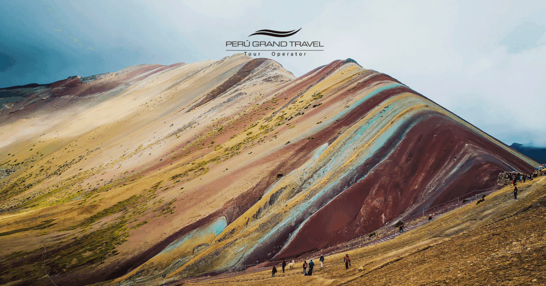
- The Base | Trailhead: Where the vehicles park, you will already be at approximately 4,600 meters (15,091 feet) above sea level.
- The Main Viewpoint | The Summit: The exact spot where everyone takes the classic photo with the mountain’s colors reaches a formidable 5,200 meters (17,060 feet).
This means you will be making an ascent with an elevation gain of about 600 meters (approx. 2,000 feet) in very thin air. The Vinicunca elevation places it higher than many of the Himalayan base camps and even higher than the highest point in Europe, Mont Blanc. It is, without a doubt, a high-mountain challenge.
But don’t let the numbers scare you. With the right planning, which we will discuss below, the conquest is perfectly viable. If you want us to handle all the logistics and emergency oxygen for you, book our Rainbow Mountain 1-Day Package.
How does the Vinicunca elevation compare to other Peru destinations?
To help our brains grasp the magnitude of 5,200 meters, we need context. If you are traveling with us and exploring the various Rainbow Mountains in Peru, here is how your lungs will feel the difference:
| Destination / Location | Elevation (Meters) | Oxygen Level (Approx.) | Sensation |
| Lima (The Coast) | 0 to 150m | 100% | Normal, easy to breathe |
| Machu Picchu (Citadel) | 2,430m | ~75% | Light fatigue, warmer climate |
| Cusco (Imperial City) | 3,400m | ~65% | Shortness of breath when climbing stairs |
| Palccoyo (The Alternative) | 4,900m | ~55% | Intense cold, flatter walk |
| Vinicunca (The Summit) | 5,200m | ~50% | Demanding effort, deep breathing |
(Host’s Note: Notice how Machu Picchu is much lower than Cusco? Many people confuse the altitudes!)
How should travelers acclimate for the Vinicunca elevation? | Beginner Tips
For many travelers coming from sea-level cities in the US, UK, or Australia, reaching the Andes is a physiological shock to the system. To face the Vinicunca elevation, you cannot rely on luck; you need Andean wisdom.
The 3-Day Rule
Never, under any circumstances, book the Rainbow Mountain tour for your first or second day in Cusco.
- The Plan: Use your first few days to explore the lower ruins or the Sacred Valley. Your body needs time to produce more red blood cells to compensate for the thin air.
The Golden Triangle of Prevention
- The Sacred Leaf: Coca tea is not a tourist myth; it is Andean science. Drink it hot upon arriving at your hotel.
- Extreme Hydration: Mountain air is very dry. You lose water just by breathing. Drink at least 2 to 3 liters of water per day.
- Light Gastronomy: Digestion is incredibly slow above 3,000m. In the dinner before your Vinicunca trek, avoid heavy meats. Opt for nutritious soups instead. Take a moment to learn about the ideal dishes in our guide on Peruvian Food.
CURIOUS FACT
The Soroche pill (Sorojchi Pills), sold in any pharmacy in Cusco, contains aspirin, caffeine, and salophene. Many travelers take them hours before reaching the Vinicunca elevation meters to dilate blood vessels and prevent headaches.
What if the Vinicunca elevation is too difficult? | The Smart Alternative
I’ll be frank with you. Some days, the body simply says “no” to extreme altitude. And there is no shame in that.
If you are traveling with family (with young children), with older parents (check our Peru for Seniors guide), or if you simply detest steep climbs, I have the perfect “Plan B.”
The Sophisticated Choice: Palccoyo
You don’t have to sacrifice the rainbow. For an in-depth analysis of these two destinations, I invite you to read our full comparison: Vinicunca vs. Palccoyo.
- Although Palccoyo also has a formidable elevation (4,900 m / 16,076 ft), the hike is almost entirely flat and lasts only 30 to 45 minutes.
- We drive you almost to the top. It is the luxurious way to appreciate the same geological miracle. Explore this option on our booking page: Palccoyo Mountain 1 Day.
Adrenaline with Comfort: ATVs
For those who want the Vinicunca view but want to skip a large part of the grueling hike, ATV Tours in Cusco are the new trend. You ride through a majestic valley, drastically cutting down physical effort and exposure time to extreme altitude.
What to wear to survive the Vinicunca elevation? | The Cold Factor
The Vinicunca elevation doesn’t just bring a lack of oxygen; it brings Ice Age cold. You will be only a few miles away from the snowy peak of Ausangate.
The wind at the summit of Rainbow Mountain is biting. The sun burns, but the wind freezes. How should you dress?
- Layering System | The Onion: Start with a thermal base layer. Add a warm fleece and, crucially, a waterproof windbreaker on top.
- The Extremities: An alpaca wool hat, wind-resistant gloves, and sunglasses with strong UV protection (the sun’s reflection on nearby ice is blinding).
Don’t be fooled by Instagram photos with flowing dresses at the top; those are only taken for the moment of the click. For the hike, functionality is true elegance.

Frequently Asked Questions | FAQ
1. How difficult is the hike to Vinicunca?
The hike is considered challenging to difficult, primarily due to the altitude rather than the terrain’s technicality. The final stretch is quite steep.
2. Can you get altitude sickness at Rainbow Mountain?
Yes, altitude sickness (Soroche) is common if you aren’t acclimated. Symptoms include headaches and nausea. We always carry emergency oxygen on our tours to assist.
3. What city in Peru has the highest elevation?
While La Rinconada is the highest town in Peru (and the world), most tourists stay in Cusco (3,400m) or Puno (3,800m) before heading to Vinicunca.
4. Why is Vinicunca famous?
It is a natural wonder of the world due to the sediment of minerals that created its seven colors. It was only “discovered” recently when the snow covering it melted due to climate change.
5. How long does it take to hike Vinicunca?
The ascent usually takes 1.5 to 2 hours, depending on your pace and how your body handles the Vinicunca elevation.
6. Should I worry about altitude sickness in Peru?
You should be prepared, not worried. With 2-3 days of acclimatization in Cusco and proper hydration, most travelers conquer the summit successfully.
An Achievement Worth the Breath
My friend, the Vinicunca elevation is intimidating in numbers, but the reward it offers justifies every slow step you will take on that colorful earth.
Reaching the 5,200-meter summit is a physical reminder that Peru is a country carved in divine proportions. You don’t just visit the Rainbow Mountains; you conquer them with respect and patience.
At Peru Grand Travel, we don’t just rent vans. We prepare you, carry emergency supplemental oxygen on all our Vinicunca and Palccoyo tours, and ensure our expert guides set the perfect pace for your heart and lungs.
Are you ready for the challenge that will change your journey?
Contact us today, and let’s include this natural wonder in your itinerary safely and unforgettably.

Experiences

Machu Picchu Challenge 8D/7N
Cusco, Sacred Valley Humantay Lagoon, Rainbow Mountain & Machu Picchu.
View Tour
Colonial Lima and Sacred land of the Incas 7D/6N
Lima, Cusco, Sacred Valley & Machu Picchu.
View Tour